The weekly blog post idea has once more fallen by the wayside. And once more, it is because of worthwhile activity. This time, I went on a holiday to Lillooet. It was a great trip, primarily spent lounging in the shade at Seton Lake, visiting in-laws, swimming in the lake, a little canoeing, and some impromptu car repairs. The cherry on top was an excursion to the Bridge River site (EeRl-4): today’s topic.

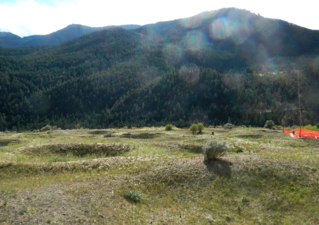
The Bridge River site, looking towards the river. The University of Montana’s tarped excavation is visible on the right. Please excuse the lens flares.
The Bridge River site is one of several major housepit sites scattered along the mid-Fraser River Canyon. The Keatley Creek site, on the Fraser’s East Bank may be more well known and is somewhat larger with something like 130 housepit depressions, but the Bridge River site has over 80 housepits, a moderately spectacular setting above the Bridge River canyon, is visible on Google Earth (go look for it yourself- you’ll spot it with an eye altitude of ≤2km. Keatley is in high definition now too), a reconstructed pithouse, and a rapidly increasing body of research and publications led by Anna Marie Prentiss out of the University of Montana. Most of all, however, Xwísten (the Bridge River band) offers a rather excellent guided tour of the site.
I showed up at the Xwísten Experience tour office/shack (located just off Moha road before the Bridge River bridge, a 5 or 10 minute drive from town) on Thursday afternoon, ponied up my $25, was handed a chunk of bear jerky (not normally part of the tour- just my lucky day I guess) and became the sole tourist following my guide: Joshua Jack. I should perhaps mention that my upcoming Ph.D. dissertation research is going to focus on lithics the BC interior Plateau, and that for the last 6 months I have been consuming just about every scrap of literature available on the archaeology of the region; mostly on the archeology around Lillooet. So Joshua, two weeks before heading off to start college in the city, was stuck with the moderately unenviable task of guiding some smart-ass bookworm around the site, fielding a plethora of questions spawned by months of study and cogitation. I was pleased to find that not only was Joshua familiar with the research done at the site (he seems to have more or less committed Prentiss and Kuijt’s recent book to memory), but he also participated in a University of Montana dig (so he knows the really new research that the rest of us have to wait months to read about), and best of all, he seems to know a lot about the community knowledge and history of the site, St’át’imc landscape use practices, regional history, and the effects of colonization/provincial and federal government policies/etc. Needless to say, he makes a heck of a guide! I was remiss in not getting a good photo of him at the site.
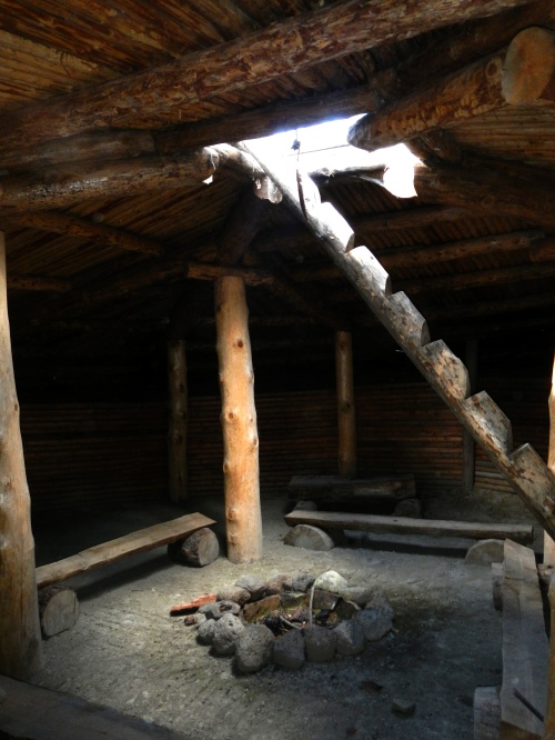
The site itself is impressive, to say the least. A reconstructed pithouse (a semi-subterranean dwelling common in the BC southern Interior after ~5000 BPish) stands at the entrance to the site, providing the visitor with an idea of what each depression represents. Unlike the pithouse at Xá:ytem, which has a concrete foundation, the Bridge River reconstruction uses entirely traditional materials. Its only deference to its status as a tour ornament rather than a functional pithouse is that the sides have been shored up with timber walls rather than being packed earth benches. In any case, it is a great addition to the site and has a very special ambiance. I can’t imagine living in one all winter with my 40 or 50 closest relatives and friends, though.

The reconstructed pithouse. Cool in the summer, warm in the winter; just as advertised. I’d like to come back in the later fall or early spring to see if it leaks, though.
Beyond the reconstruction, the Bridge River site is something of a lunar landscape, pockmarked with dozens of housepit depressions. The housepits are pretty substantial, and many are surprisingly deep. Indeed, they often “feel” deeper than their counterparts at Keatley Creek. That may just be my imagination, though. As I mentioned earlier, the University of Montana has been busy at Bridge River. The evidence of their most recent excavations remain in the form of a tarped-over housepit. While I can’t be sure without peaking under the tarp, I got the impression that this year’s dig may have been a pretty intensive excavation of a single feature. With the glut of recent work coming out of there (4 or 5 theses, a bunch of articles, and a pretty skookum book since 2010 alone) I look forward to seeing the results of the 2012 season.

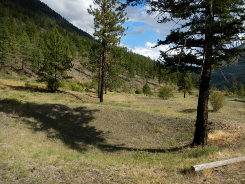
A housepit with a convenient tree shadow to give it a little contour. The round lumber in the lower right is part of the border of the path to keep tourists from tromping all over the place.
What was supposed to be an hour tour stretched to something like 90 minutes, followed by another half hour hanging out at the tour HQ shooting the breeze, ogling artifacts, checking out archival photos, and watching folks dipnet fishing from the rocks at the rapids. I really wish that I had allotted a bit more time and had gone on the fish-station tour and then had the BBQ at the end (though they might not have fired up the grill for just one person). I’ll most certainly be back for that next year. I strongly recommend stopping in when in the Lillooet area.
There is a lot to like about the Bridge River site tour. First off, it provides a very good introduction to the archaeology of the region. I’ve had about enough of folks talking about how BC/Canada has “no history”. The tours here not only show evidence of some pretty deep history (aside from Stonehenge and maybe Skara Brae, I’ll bet the average person would be hard pressed to name a handful of pre-2000 BP sites in the UK), but they also show very clearly the continuity between the ancient site occupants and the folks who live right down the road today. The idea of the vanished/vanishing native is elegantly done away with, as visitors to the site would have to be extremely myopic not to notice people fishing from the same rocks as their ancestors have fished from for thousands of years, yet without being locked in some sort of time-warp. Also, by running the tours, the Xwísten have taken some control over the narrative of the site. The archaeological data seems to come pretty directly from Prentiss and her colleagues, but its integration with family histories, personal anecdotes, and community lore is what stands out. These latter narratives enrich the tour experience in a way that most tours cannot match (even the excellent information-laden ones like at MOA). Indeed, it got me thinking differently about the orientation of the mid-Fraser hinterland(s), and how that might affect social networks, settlement patterns, and resource use. All in all, if you’re at all interested in the history and prehistory of the region, and you have to choose to either buy the Prentiss and Kuijt book or go to Lillooet and go on the tour, the decision is easy: go on the tour. You’ll come away with much more (and it’s cheaper). Plus, they sell the book at the desk of the tour shack so you can always pick up a copy while you’re there.

Great little review, a native friend from Lillooet posted it on FB….just some quibbles about style….I’ve never understood the second-word lower case thing as evidenced here by a couple of things, I think it’s because of Wikipedia’s MOS’ influence on language use, as they apply the second-word lowercase to lots of things that are just WRONG and defend it with passive-aggressive fury….and I’m picky about the language on my homescape in particular. For instance “Moha Road” is a proper name and isn’t “Moha road”……in local parlance it’s also “the Moha Road”, but never mind that….we usually just say “the Moha” in fact, though that also means a particular landform to those who know what it is. Another one like this is “Bridge River bridge”, which is “Bridge River Bridge”, redundant as though that looks; it’s a proper name.
The one that always gets me and has gotten me in fights with academics and journalists, often from Central Canada, is not capitalizing “the Interior”, which is the proper name of a region in BC, as is “the Interior Plateau”…here, curiously, you’ve got “BC interior Plateau”….but later “BC’s southern Interior”, this usage is usually fully capitalized…..likewise “Bridge River Canyon”, though true that capitalized usage really is used more for the stretch from Moha to Terzaghi Dam (which if you didn’t see, you missed out, it’s Canada’s Yosemite but without the parking lots and hordes of climbers and campers).
Nice to see the word “skookum” used here, I gather you’re actually from BC or the Pacific Northwest then, but wonder how many people from outside the region would get it.
Just quibbles, great little essay. Might be worth noting also that the area’s history is also rich from a succession of gold rushes and settler history, also, not just archaeological and native culture….
Thanks for the feedback, Mike. As you figured out, most of my errors are due to me not being from around Lillooet, so my exposure to the Moha Road has been limited to the street sign by the gas station in town, and seeing business addresses written as “1234 Moha Road” (or something along those lines). A lot of the rest are related to the whole thing being written on the fly, with only a very cursory proofreading before posting. I reckon I’ll give things a rectifying edit on the weekend.
That said, the points you raise regarding capitalization of “southern Interior”, “interior Plateau”, etc. got me thinking. Aside from the geological boundaries of the Canadian Plateau, how does one define the Southern/southern Interior/interior. If Environment Canada is to be believed, the latter includes all of HWY 20 out to Bella Coola (which seems less interiorish to me), and north beyond Quesnel. From a biogeoclimatic perspective, the boundary should be closer to Clinton, with Williams Lake, Quesnel, the Chilcotin, and the Nechako all classified as Central Interior. Alternatively, one could base in on drainages, and say that regions the feed the Fraser (above Hope, maybe) and the Columbia are the Southern Interior, and the Skeena/Stikine/MacKenzie/etc. define the north of the province.
Ethnolinguistic definitions add even more dimensions. There, according to anthropologists, the Plateau groups are theoretically defined as the St’át’imc, Secwepemc, Okanagan, Similkameen, Nlaka’pamux, and Nicola. It seems to conform closely enough to geographic boundaries, but then you look at the western reaches of St’át’imc territory, and it’s reaching all the way into the Pemberton Valley, Lillooet Lake, Harrison Valley, etc. all of which which seem a lot more coastal in terms of climate, ecology, and drainage.
I plan to do a post or two on goldrush/settler history and archaeology at some point too, but my primary interest is in the precontact archaeological material, and I’ve got a couple other post ideas lined up along those lines, so it may be a few weeks before that comes about.
Awesome!!
Thanks, Leslie! Have you been to the site?